European Hiking Compass 2.1
Paid Version
Publisher Description
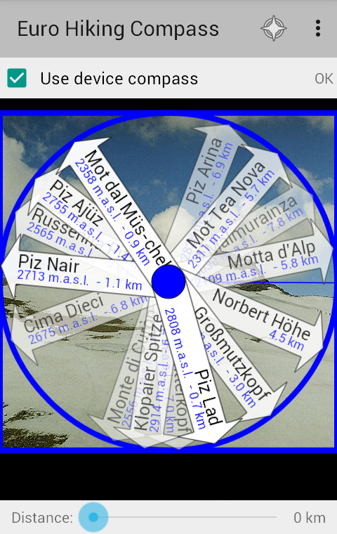
This is the app for everyone who likes hiking in Europe. Whether it's the Alps, the Carpathian Mountains, the Pyrenees or somewhere else. The app will show you name and distance (and sometimes altitude) for the most important hill and mountain tops in the terrain around you.
When your device is flat you see a compass with arrows pointing towards the tops, and when it's held upright you see an augmented reality camera view. In camera view you can take photos, and the names of the tops and other places will be printed on the picture. The app can also display a map, where tops whitin a radius of approximately 60 km are marked. Swipe over the screen to swap between compass and map.
You can choose if you want arrows/markers for all available hills and mountains, or if you prefer mountains only. You can also choose to see other terrain formations like valleys and capes, waters and lakes, or other names like populated places.
The app uses offline data, which means that it will also work without an Internet connection. But there are a few exceptions: You need Internet connection if you want to download new maps. These will be temporary stored on your device, and consequently work partly offline later. You also need Internet connection the first time you are starting the app, so it can do a piracy check. A new check on this will be done at least every third month.
---
Want to test before your buy? Check out the free app "Norwegian Cities and Villages":
https://play.google.com/store/apps/details?id=com.spillby.android.norskekommunesenter
It show different (Norwegian) data, but work in a similar way as the Euro Hiking Compass (you can use a fake GPS app to pretend you are in Norway).
Something you are missing in the app? Tell me on Facebook or send an e-mail!
Didn't like the app after all? I give a one month guarantee: Send me an e-mail and tell me what you didn't like, and I'll refund your money if I can't fix it.
Data source: Geonames.org, licenced under Creative Commons Attribution. The data covers all of Europe, from Iceland, Svalbard, Gibraltar, Istanbul and at least parts of the Ural Mountains.
Note: The first time you run the app it will need 2-4 minutes to prepare its data source.
About European Hiking Compass
European Hiking Compass is a paid app for Android published in the Recreation list of apps, part of Home & Hobby.
The company that develops European Hiking Compass is Christian Berge. The latest version released by its developer is 2.1.
To install European Hiking Compass on your Android device, just click the green Continue To App button above to start the installation process. The app is listed on our website since 2015-05-24 and was downloaded 2 times. We have already checked if the download link is safe, however for your own protection we recommend that you scan the downloaded app with your antivirus. Your antivirus may detect the European Hiking Compass as malware as malware if the download link to com.spillby.android.eurohiking is broken.
How to install European Hiking Compass on your Android device:
- Click on the Continue To App button on our website. This will redirect you to Google Play.
- Once the European Hiking Compass is shown in the Google Play listing of your Android device, you can start its download and installation. Tap on the Install button located below the search bar and to the right of the app icon.
- A pop-up window with the permissions required by European Hiking Compass will be shown. Click on Accept to continue the process.
- European Hiking Compass will be downloaded onto your device, displaying a progress. Once the download completes, the installation will start and you'll get a notification after the installation is finished.
